


By Beta Via
How drone-based hyperspectral sensing enables proactive wildfire risk assessment within the ICAERUS Forestry and Biodiversity Use Case
Wildfires are among the most destructive forces threatening European forests. As climate change drives longer droughts, higher temperatures, and more frequent extreme weather events, the conditions for large-scale fires are becoming increasingly common. Preventing catastrophic fire damage requires moving beyond reactive responses and developing robust, data-driven tools that can identify risk before ignition occurs.
Within the ICAERUS project, the Forestry and Biodiversity Use Case addresses this challenge through a dedicated Wildfire Risk Monitoring scenario. By deploying UAVs equipped with hyperspectral cameras, the workflow generates detailed, high-resolution maps of forest fuel types and their condition—providing the spatial intelligence needed to support fire prevention planning, resource allocation, and early warning systems.
Beta Via contributes expertise in UAV data acquisition, hyperspectral imaging, and geospatial analysis to advance this proactive approach to forest fire risk assessment.
Site Selection: Starting with Risk Intelligence
The monitoring workflow begins well before any drone takes flight. Test sites are selected using a combination of natural fire potential classes and historical fire records. These inputs provide a scientific foundation for identifying forest areas where environmental conditions are most likely to support ignition and rapid fire spread.
Natural fire potential classes help identify regions where environmental conditions—such as dryness, vegetation type, and fuel accumulation—create elevated risk. Historical fire records add an empirical layer, revealing where fires have occurred before and under what conditions. Together, these inputs enable targeted deployment of UAV resources toward the highest-priority locations.
This evidence-based site selection approach ensures that monitoring effort is concentrated where it delivers the greatest value, optimising both the scientific output and the practical impact of the data collected.
UAV Hyperspectral Mapping of Forest Fuels
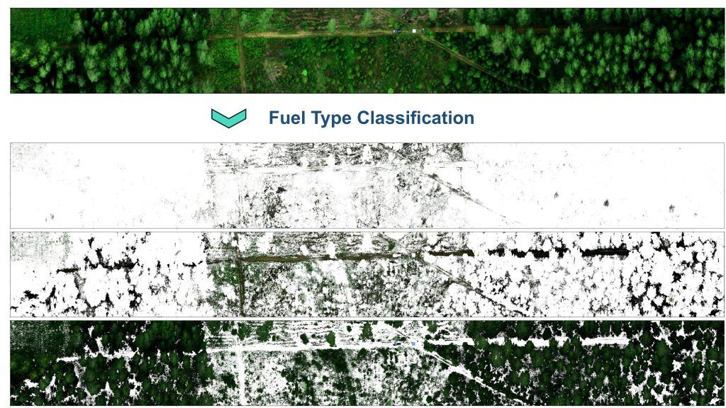
Once target sites are identified, a multirotor UAV fitted with a hyperspectral camera is deployed to conduct detailed aerial mapping. The drone acquires imagery at very high spatial resolution, capturing spectral information across dozens of narrow wavelength bands simultaneously.
The hyperspectral data enables precise differentiation of fuel types that would be indistinguishable in standard imagery. Materials classified and mapped in the field include:
- Dry grass and herbaceous ground cover
- Leaf litter and pine needle accumulations
- Deadwood and fallen branches
- Shrub layers and understorey vegetation
- Other combustible materials across the forest floor and canopy
Beyond classification, the hyperspectral sensor also captures data on moisture content and vegetation condition across the study area. Both parameters are critical for understanding not just what fuels are present, but how readily they would ignite and sustain combustion under given weather conditions.
Beyond RGB: The Advantage of Hyperspectral Sensing
Standard RGB cameras, the most common form of drone-mounted imaging, capture only three broad colour channels—essentially replicating what the human eye can see. While useful for general inspection, RGB imagery cannot distinguish between fuel types that appear visually similar but behave very differently during a fire.
Hyperspectral sensors overcome this limitation by recording dozens of narrow spectral bands spanning the visible and near-infrared portions of the electromagnetic spectrum. Each material—whether dry grass, decomposing deadwood, or stressed pine needles—reflects light in a distinct spectral pattern, known as its spectral signature. These signatures encode information about a material’s biochemical composition, moisture content, and physiological state.
This spectral richness allows the monitoring system to detect subtle differences in dryness and early vegetation stress long before any visual symptoms appear. A stand of trees showing early moisture stress, for example, will register a characteristic shift in near-infrared reflectance that a hyperspectral sensor can detect, even when the canopy still appears green to the eye.
The result is a far more accurate and actionable picture of fuel condition than any RGB camera could deliver—one that is grounded in the physical and chemical properties of the vegetation itself.
Generating High-Resolution Wildfire Risk Maps
The hyperspectral data collected by the UAV is processed through a geospatial analytical pipeline that combines spectral classification with spatial analysis. The output is a set of high-resolution wildfire risk maps showing the distribution, concentration, and condition of combustible materials across the monitored area.
These maps provide a spatially explicit view of where fuel loads are most concentrated and where conditions are most conducive to fire ignition and rapid spread. By combining spectral signatures with spatial analysis, the system delivers the detail needed to understand fire risk at the level of individual forest stands.
The maps are designed to be interpretable by forest managers without requiring specialist remote sensing expertise. Clear visual outputs allow decision-makers to understand and act on the data directly, integrating it into their existing planning workflows.
Supporting Proactive Forest Fire Management
The practical applications of UAV hyperspectral wildfire risk mapping are wide-ranging. The data and maps produced within this scenario can directly support:
- Fire prevention planning—identifying priority areas for fuel reduction measures such as controlled burns, mechanical thinning, or targeted clearing.
- Resource allocation—guiding the deployment of prevention and response resources toward the areas of greatest need.
- Early warning systems—providing the fuel condition data needed to underpin timely alerts and prevention strategies.
- Increased surveillance—prioritising areas identified as high-risk for closer monitoring and targeted management interventions such as thinning or controlled burns.
Taken together, these applications represent a fundamental shift in how wildfire risk is understood and managed. Rather than responding to fires after they ignite, forest managers can act on predictive intelligence—intervening in advance to reduce fuel loads, improve landscape resilience, and protect both ecosystems and communities.
Transforming Wildfire Risk Assessment
A core ambition of the ICAERUS Wildfire Risk Monitoring scenario is to demonstrate how UAV-based hyperspectral sensing can transform fire risk assessment from a largely reactive process into a proactive, data-driven strategy. As climate change accelerates and extreme weather events become more frequent, the urgency of this transformation only grows.
The integration of hyperspectral UAV technology into forest management workflows represents a significant step forward. By providing spatially precise, biochemically grounded intelligence about fuel conditions, this approach equips forest managers with the knowledge they need to make informed, timely decisions—before conditions become critical.
Through its contribution to UAV data acquisition, hyperspectral image processing, and geospatial analysis, Beta Via supports the development of monitoring solutions that can make European forests more resilient in the face of growing wildfire risk.
________
This article is part of a blog series presenting the Forestry and Biodiversity Use Case within the ICAERUS project.
